25.190.050 Definitions.
The following terms shall have the meanings indicated, specific to this chapter only:
“Airport” means the Tri-Cities Airport operated by the Port of Pasco including all property designated in the Tri-City Airport Master Plan as part of the airport.
“Airport authority” means the Port of Pasco.
“Airport elevation” means the highest point of an airport’s useable landing area measured in feet from sea level. The Tri-Cities Airport is 410 feet above mean sea level.
“Airport influence area” includes airport property and all land within the Airport Safety Compatibility Zones 1 through 6 as described in PMC 25.190.090 and depicted in the Airport Safety Zones map adopted by PMC 25.190.020.
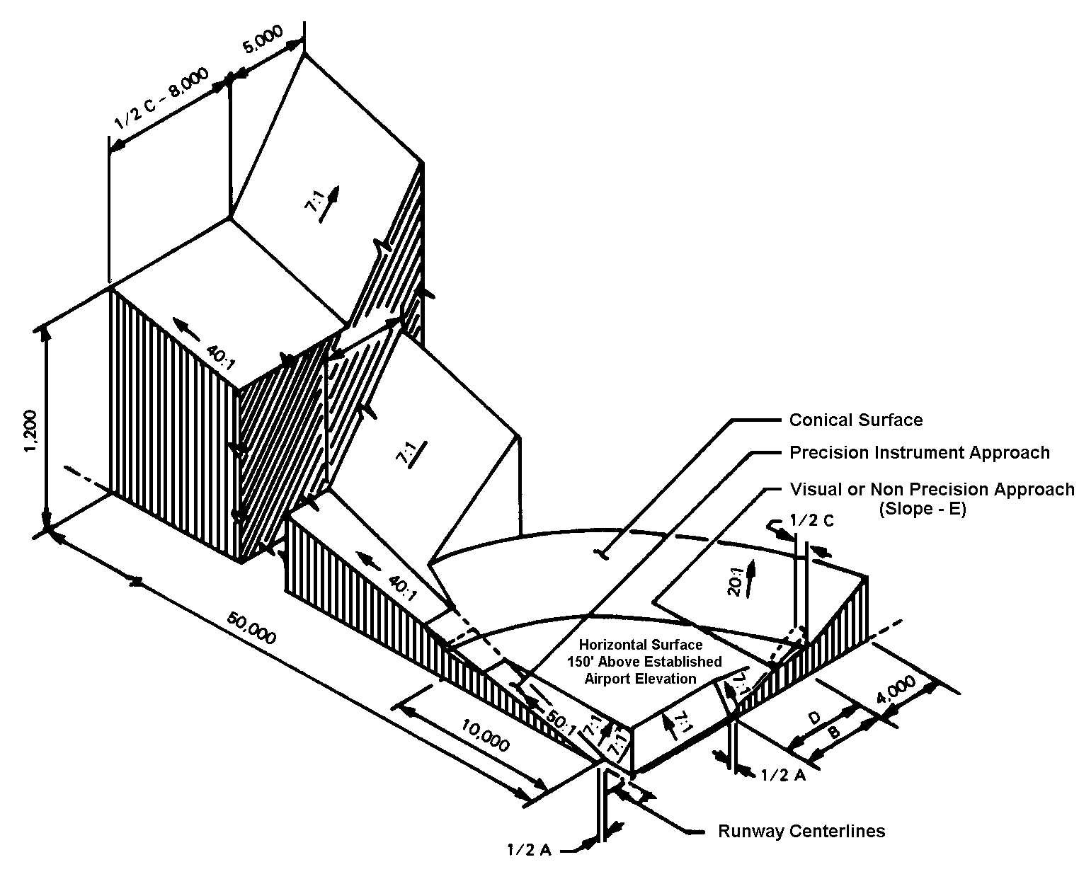
“Approach surface” means an imaginary surface longitudinally centered on the extended runway centerline, extending outward and upward from the end of the primary surface and at the same slope as the approach zone height limitation slope set forth in PMC 25.190.060. The perimeter of the approach surface coincides with the perimeter of the approach zone.
“Conical surface” means an imaginary surface extending outward and upward from the periphery of the horizontal surface at a slope of 20 to one (20:1) for a horizontal distance of 4,000 feet.
“Deed notice” means a formal statement provided in PMC 25.190.100 as a note on the face of a short plat, major subdivision or binding site plan or recorded against the property notifying potential property owners that the property is located adjacent to an active airport and said property may be impacted by aircraft noise, odors, vibration, and low-flying aircraft.
“FAA form 7460-1, notice of proposed construction or alteration” means a form which the Federal Aviation Administration requires to be completed by anyone who is proposing to construct or alter an object that could affect airspace within the airport influence area and allows the FAA to conduct an airspace analysis to determine whether the object will adversely affect airspace or navigational aids.
“FAR part 77 surfaces” means the Part of 49 CFR of the Federal Aviation Regulations that deals with objects affecting navigable airspace.
“FAR part 77 zones” means imaginary airspace surfaces established with relation to each runway of an airport. There are five types of surfaces: (1) primary, (2) approach, (3) transitional, (4) horizontal, and (5) conical.
“Hazard to air navigation” means an obstruction determined to have a substantial adverse effect on the safe and efficient utilization of the navigable airspace.
“Height” means for the purpose of determining the height limits in all zones and as shown on the Tri-Cities Airport Future Part 77 Zones map, this datum shall be height above mean sea level elevation unless otherwise specified.
“Horizontal surface” means a horizontal plane 150 feet above the established airport elevation, the perimeter of which plane coincides with the inner perimeter of the conical surface. This is 560 feet above mean sea level for the Tri-Cities Airport.
“Infill” means development on scattered vacant parcels of land which have remained vacant after the majority of development has occurred in an area.
“Object of natural growth” means a tree, shrub or similar organic or vegetative matter.
“Obstruction” means any object of natural growth, terrain, or permanent or temporary construction or alteration, including equipment or materials used therein, which exceeds a limiting height set forth in PMC 25.190.070.
“Precision approach” means a landing approach made without visual reference to the ground by the use of aircraft instruments and ground-based electronic or communications systems or devices. An aircraft making such an approach should be flying in accordance with an IFR (instrument flight rules) flight plan.
“Primary surface” means a surface longitudinally centered on a runway with a width of 1,000 feet for instrument approaches and 500 feet for visual approaches. When the runway has a specially prepared hard surface, the primary surface extends 200 feet beyond each end of the runway. The elevation of any point on the primary surface is the same as the elevation of the nearest point on the runway centerline. The elevation of the primary surface at the Tri-Cities airport is 410 feet above mean sea level.
“Runway” means a defined area on an airport prepared for landing and take off of aircraft along its length.
“Transitional surfaces” means the imaginary surfaces extending outward at 90-degree angles to the runway centerline, and runway centerline extended, at a slope of seven feet horizontally for each foot vertically (7:1) from the sides of the primary and approach surfaces to where they intersect with the horizontal and conical surfaces.
“Visual runway” means a runway intended solely for the operation of aircraft using visual approach procedures, with no straight-in instrument approach procedure and no instrument designation indicated on an FAA-approved airport layout plan. [Ord. 4111 § 2, 2013; Code 1970 § 25.81.050.]